EARLSDON
AREA OF LOCAL DISTINCTIVENESS


Definition of the Area of Local Distinctiveness


Terracotta detail


The area defined in this document was determined by the working group following detailed discussions based on the following criteria:

  • That the area was clearly identifiable and was determined by clear boundaries.

  • That the streets included buildings and other features worthy of recognition.

  • That the streets included did not already hold other designations, e.g. Conservation Area status.

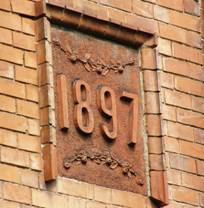
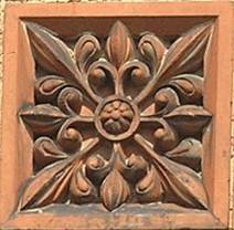
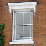
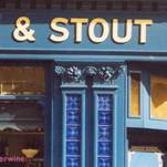
On this basis it was decided to divide the Earlsdon Area of Local Distinctiveness into five zones.  Each zone represents a stage in the growth of Earlsdon and contains good, typical examples of architecture from the mid-Victorian period to the end of the Edwardian period.  The five zones are contained within an area bounded by Beechwood Avenue to the south and west, the Coventry/Birmingham railway line to the north and the Kenilworth Road Conservation Area to the east.  In a few instances other examples of distinctive buildings have been included which are outside of these boundaries. The working party agreed that the starting point should be the original eight streets laid out by the Coventry Freehold Land Society, i.e. Earlsdon Street, Moor Street, Warwick Street, Clarendon Street, Arden Street, Providence Street, Berkeley Road South and a short stretch of Earlsdon Avenue South.  These streets were developed from 1852 and form Zone One.


Arden Street
Arden Street


The economic decline of Coventry and the collapse of the watch making industry from the 1870s is apparent in the lack of development in Earlsdon.  Zone Two developed after 1891 with the emergence of the forerunners of the cycle, motor and machine tool industries which led to the economic prosperity of the city in the mid twentieth century.  The six roads (Stanley Road, Radcliffe Road, Palmerston Road, Shaftesbury Road, St.Andrew’s Road and Rochester Road) in Zone Two linked the original eight streets with Beechwood Avenue.  Beechwood Avenue, originally known as Whor Lane was an old well established track between the Kenilworth/Coventry Road and the London/Coventry Road.  The four roads in Zone Three (Osborne Road, Avondale Road, Styvechale Avenue and Warwick Avenue) developed slightly later after 1897 and provided some larger housing for the managers and owners of the new industries.  These roads led to Beechwood Avenue which was the main and only road linking Earlsdon via the Kenilworth Road with the City of Coventry.


The four roads in Zone Four (Poplar Road, Earlsdon Avenue North, Newcombe Road and Albany Road) were developed after 1897.  The opening of Albany Road in 1897 was in response to need for housing by the workers in the emerging engineering, cycle and car industries.  Albany Road followed the line of the Earlsdon Jetty, which was the most direct, shortest, if sometimes treacherous and unpleasant pedestrian route to Coventry.  The roads also linked the original eight streets with Chapelfields and Coventry.  By the time Zone Five commenced (Earlsdon Avenue South, Belvedere Road, Stanway Road, Mickleton Road, Huntingdon Road, Mayfield Road, Berkeley Road North, Broadway, Spencer Avenue and Dalton Road) from 1910, the new industries were becoming well established.  The workers, managers and owners of the new firms all needed housing.


Useful Links:

EOL
ECAD
Earlsdon History and Heritage


Return to index

This site is hosted by EOL and Coventry University